To Do
Marquette Harbor Lighthouse
300 N Lakeshore Blvd, Marquette, MI 49855
https://mqtmaritimemuseum.com/marquette-lighthouse
Lighthouse Tour Information
- All tours must be escorted by museum staff/volunteer
- Tours leave from museum entrance
- Walking tour – must be able to climb 45 steps
- Tour consists of history of Lighthouse Park, Coast Guard, two floors of lighthouse, and catwalk.
- The Lighthouse restoration process is ongoing. The second floor is the latest restoration.
- Tours do not run in inclement weather
- Tour lasts approximately one hour
- All visitors must stay with the tour guide at all times
Tour Times: 11:30 am, 1:00 pm, and 2:30 pm, Tuesday through Sunday (closed Mondays)
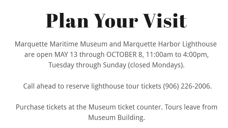
Marquette Maritime Museum and Marquette Harbor Lighthouse
are open MAY 13 through OCTOBER 8, 11:00am to 4:00pm,
Tuesday through Sunday (closed Mondays).
Call ahead to reserve lighthouse tour tickets (906) 226-2006.
Purchase tickets at the Museum ticket counter. Tours leave from Museum Building.
Museum Tickets - $10/adult; $8/seniors
Lighthouse Tickets - $10/adult; $8/seniors
Both Tickets - $18/adult; $15/seniors
Marquette Maritime Museum
300 Lake Shore Bld, Marquette, MI 49855
https://mqtmaritimemuseum.com/plan-your-visit
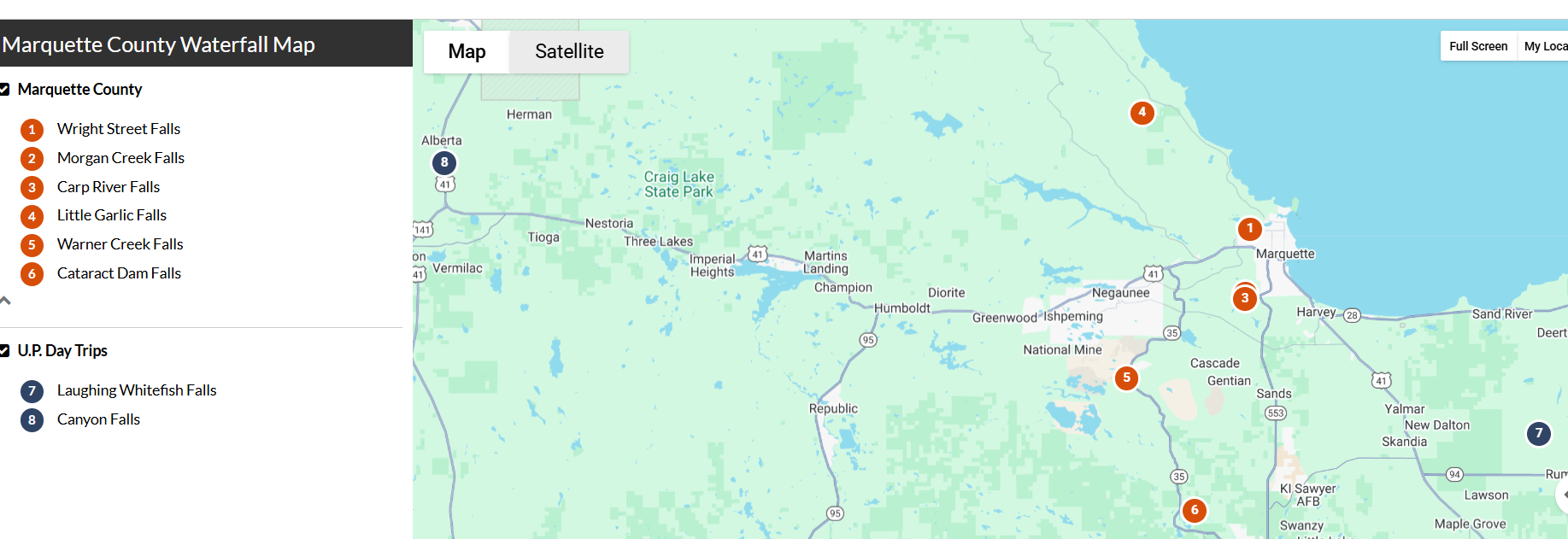
Warner Falls
GPS: 46.43333, -87.59888
Drive: 16 mi, 22 min (from downtown Marquette)
Drop: 20 ft
Warner Falls is located just outside of Palmer, 20 miles southwest of Marquette on M-35. While this waterfall can be viewed from the highway, it’s best appreciated from a closer vantage point. Park your car past the guard point (fully off of the road), and follow the signage to the trails to see this small but mighty fall among autumn’s glorious orange and gold foliage.
Directions:
-
Head south on Front St (0.339 mi)
-
At the traffic circle exit west on US-41 N (0.523 mi)
-
At the next traffic circle, take the third exit onto Grove St (2.21 mi)
-
Turn left onto Co Rd 492 (4.33 mi) → Turn left on M-35 South (8.16 mi) → Park on the right side of M-35, the falls are a short trail hike west
Rare Earth Goods & Café
Address: 200 E Division St, Ishpeming, MI 49849
Old Town Negaunee
You’ll find skeletal remains of a once-bustling mining town with nature reclaiming streets, stairwells, and sidewalks that lead to nowhere.
Address: Negaunee Downtown Historic District, Negaunee, MI; Between Peck St and Rail St AND Tobin St and North Teal Lake Ave)
Old Catholic Cemetery
Little more than a sign and a path in the woods now since most of the tombstones were removed in the early 1900s. However, not all the bodies were found, and neighbors have reported commotion in the area.
Address: Holy Cross Catholic Cemetery, 1400 Wright St, Marquette, MI 49855
Jilbert Dairy
200 Meeske Ave, Marqeutte, MI 49855
Thomas Rock Scenic Overlook
County Road 510, Big Bay, MI 49808
This popular vista point is only minutes from downtown Big Bay. From Marquette, take CR 550 approximately 23 miles, then turn left onto CR 510, and in a mile, the entrance will be on the right. This one-mile ADA-accessible trail offers excellent views of Big Bay, Lake Superior, and on a clear day, the Keweenaw Peninsula. Amenities include on-site toilets near the parking lot, and railings and benches along the path. As you walk along the wide trail, keep an eye out for informational posts describing the local wildlife and plants. Thomas Rock is a nice hike for visitors of most skill levels, as it offers a fun and easy excursion. Family-friendly. Dog-friendly.
Top of the World Scenic Overlook
A scenic overlook where the view is too good not to share! It’s also easy to get to if you don’t have a lot of time for a long hike. To get there, head out to Harlow Lake via 550 from Marquette. Turn down Harlow Lake Road and drive up the steep dirt road until you see a parking area and trailhead on your right. You can only do this drive in the warmer months because at some point in the winter the road will not be plowed. Once you park, it’s a short uphill climb to two huge rock outcroppings with unobstructed views all the way down to Lake Superior. You can see Little Presque Isle, Hogsback Mountain, Sugarloaf Mountain from up here too. Little Fern has made the trek several times and has yet to see the view. We’ll have to remedy that one day!
Echo Lake
Echo Lake must be a well-kept secret because we rarely see anyone else out on the trails. This 480-acre Nature Conservancy property is just past Harlow Lake and offers two different hikes for visitors. One is an overlook with views of the colorful woods and the other winds around the peninsula that juts into the lake offering a clear view of the colorful forest. It’s also incredibly quiet out here, no road noise at all. The Peninsula Trail is .4 miles down to the water and an easy walk. If you have little ones with you or people not as experienced with hiking, this trail is much easier than the Overlook Trail. If you’re looking for something a bit more challenging, the Overlook Trail is .6 miles and a steady climb up. The forest is quite thick so the view isn’t as dramatic as others but it’s still beautiful.
Mount Marquette
If you want a view of the lake and the city of Marquette without any hiking, drive up to the top of Mount Marquette. On a clear day, you can see a quilted landscape of autumn colors and the entire city of Marquette, including Northern Michigan University’s Superior Dome and the Ore Dock. This point is easy to find using app navigation but drive south of town to 553 and turn on Mt. Marquette Road and drive to the top. This is a one-way road and quite steep so I’d only drive it if you have 4wheel drive.
Mount Marquette, not to be confused with Marquette Mountain, offers an extensive city view accessible by car or on foot, making it ideal for explorers of all ages and abilities. Located just two miles east of downtown Marquette, visitors can reach this scenic spot by turning left on Cliff Power Road. This one-way drive takes you to the top of the mountain and back down to County Road 553.
The road to the summit can be a bit rugged, narrow, and steep, but the short drive is well worth it for the unique vantage point it offers. Note that it's a seasonal road, only open to snowmobiles in winter. From 1,200 feet up, you can experience Marquette from a different perspective and take in the all-encompassing view of the city and Lake Superior.
To reach the top, follow Mt. Marquette Road as it winds up the mountain. At the summit, park your car and head to the outlook area for a spectacular view. There are several viewing areas: the first requires a few steps up over rocky, uneven terrain, while the second offers easier footing, walking over flatter terrain. Both provide breathtaking panoramic views of Marquette and its surroundings.
Sugarloaf Mountain
Short but sweet — this scenic hike is popular among locals and visitors alike, for good reason. Standing at an elevation of 470 feet, Sugarloaf Mountain in Marquette, MI offers a unique outdoor experience with its rocky terrain and Superior views.
The half-mile trail is well-marked and takes approximately 15 to 30 minutes to reach the top. Take the 'easy' way for tamer terrain or the 'difficult' route for a faster, steeper climb. Be prepared to step over rocks and roots. The climb includes multiple staircases and is rated "moderate" in difficulty. The rewarding sights, however, are worth the effort.
Sugarloaf Mountain is located about six miles north of downtown Marquette on CR 550. Get there by taking Washington Street to Fourth Avenue. Turn north onto Fourth Ave., which becomes Presque Isle Ave and drive .4 miles to Hawley Street. At Hawley Street, turn west (left). Hawley becomes CR 550. Drive about 4.0 miles on Hawley Street/CR-550 to the parking area. A sign that reads “Sugarloaf Mountain” marks the parking area and is easily visible from CR 550.
On a recent hike, my first time to Sugarloaf Mountain, two friends and I took the “difficult” route and made it up in about fifteen minutes. There’s an optional “easy” route with a tamer grade that takes a little longer, but both paths up the mountain do require a extra care as rocks and roots stick out of the ground along much of the path.
Most people come to Sugarloaf for the view, but the forest canopy that envelops the trails is worth mentioning. With century old trees and ancient rock outcroppings, this trail reminds me of a few of the better hikes I’ve done in the rainforests of Australia. It really is a gorgeous area.
As we approached the top, the dirt trail switched to a series of wooden stairs that brought us up to the viewing area. At the top we were rewarded with a stunning view of Lake Superior, Marquette, Presque Isle Park and Little Presque Isle as well as Hogsback Mountain and the large swath of forest between Marquette and Big Bay.
The summit of Sugarloaf Mountain provides panoramic views from three observation platforms, each with distinct vantage points that offer a serene setting for nature watching and photography.
The south-facing observation deck offers views of the city of Marquette, showcasing landmarks such as the Superior Dome, the Upper Ore Dock, and Presque Isle Park.
The east-facing deck overlooks the vast Lake Superior shoreline with views of Wetmore Landing and Little Presque Isle to the north.
The west-facing platform provides splendid views of the Huron Mountains and Hogsback Mountain.
Harlow Lake
No matter the season, this is the spot we got most often. There are tons of trails in this area that are dog-friendly and rarely crowded. Pack some happy hour supplies so after your hike, take in the sunset overlooking the lake. There is a parking area right by this giant outcropping which makes it really easy to climb up and enjoy the view while the sun goes down. No need for 4wheel drive to get to Harlow Lake and trailheads.
Presque Isle Park Overlook
This is one of the most popular places in town and it’s easy to see why the first time you visit. It’s over 300 acres of forest, trails, and some of the most beautiful views of Lake Superior and fall foliage. Frederick Law Olmstead (yep, Central Park Olmstead) visited Marquette in 1891 and recommended the city leave it alone so the public could enjoy its natural beauty. There’s free parking if you want to walk through the park but if you’re pressed for time, you can always drive the one-way loop for a gorgeous drive. When we have visitors in town we typically take them here first to do a quick drive through the park and take a walk over the prehistoric Blackrocks formation and photos at Sunset Pointe. We’ve yet to do it but if you’re really brave, you can jump off the Blackrocks into the freezing water.
CR 510 Bridge View
Co Rd 510, Negaunee, MI 49866
Family and dog friendly, use caution. Accessible by car.
Marquette Multi-Use Path
Walking along the Lake Superior shoreline is one of the best things to do in Marquette Michigan during the spring. The Multi-Use Path is a paved network that stretches for more than 17 miles.
From Presque Isle in the north to wooded paths in the south, it passes through some of Marquette’s most scenic and historic areas. You can access the trail via Founders Landing Park, Mattson Park, Presque Isle Park, Shiras Park, and South Beach Park. It even connects to the Noquemanon Trail Network’s South Trails.
McCarty’s Cove
Like a scene out of a movie, you can see Marquette Harbor Lighthouse from the small beach at McCarty’s Cove. You can swim from the sandy Lake Superior shoreline — where the water is slightly warmer than at other beaches on the lake — to the lagoon and rock islands.
Summer is the best time to go because there’s a lifeguard on duty. Along the beach are volleyball nets, benches, a picnic area, and a playground.
Presque Isle Park
Visiting Presque Isle Park is one of the best things to do in Marquette Michigan during the summer because of everything that it offers. It features a few pebble beaches where you can swim when the waters are calm. You can launch canoes, kayaks, and stand-up paddleboards from these beaches as well.
A unique feature in the park, Black Rocks is an ancient rock formation that’s about 1.7 billion years old. Standing 20 to 30 feet above the surface of Lake Superior, it’s a spot where many locals and visitors go cliff jumping.
Presque Isle Park has a 2-mile loop — Peter White Dr. — that closes to vehicle traffic at certain times of the day so that visitors can bike and walk the park without worry. You can learn about plants and wildlife on the interpretive signs of the Bog Walk and Nature Trail.
On top of these activities, you can climb The Pinnacle, a rock formation situated just beyond the observation deck.
Little Presque Isle
Worth the 15-mile drive, Little Presque Isle is northwest of downtown Marquette. With heavily timbered forests, rugged cliffs, and sandy beaches, the locals consider it a crown jewel of Lake Superior.
Because of that, the peninsula offers hiking, swimming, and wildlife viewing in a single place. You have the opportunity to watch the Northern Lights at night, and the sky is clearer than some other places because it’s away from the city lights.
Michigan Iron Industry Museum
Among the many free attractions, the Michigan Iron Industry Museum is one of the best things to do in Marquette Michigan. It overlooks the Carp River and is the site of the first iron forge in the region.
Open Wednesdays through Saturdays, the museum rests amid the forest gorges of Marquette Iron Range. You can take a 1 to 2-hour tour of the temporary and permanent exhibits, as well as interpretive trails.
Big Bay Point Lighthouse
Lighthouse and B&B! Includes a spa.
Located 25 miles north of the historic town of Marquette and nestled on the cliffs of Lake Superior, rests the Big Bay Point Lighthouse Inn.
A great place for adults in search of a secluded retreat from modern life. This unique bed-and-breakfast inn is one of the few surviving resident lighthouses Inns in the country and is listed on the National Register of Historic Places.
GPS coordinates are W 87.40.480 North 46.50.280 If your GPS takes you onto a two track road through the woods, turn back to the paved road. Lighthouse Rd is now paved.
All RESERVATIONS need to be made through our secure website and not over the phone or in person. Our cell service can be spotty, so please send us an email, and we can coordinate a time to call you. Email: bigbaypointlighthouse@gmail.com
Huron Island Lighthouse
A great trip for history buffs, the Huron Islands are eight rocky islands within Lake Superior. Built in 1868, the Huron Island Lighthouse is a granite school-styled structure isolated on one of the Huron Islands just 3 miles off Michigan’s Coast. The Huron Island Lighthouse is listed as part of the National Register of Historic Places.
https://lighthousefriends.com/light.asp?ID=729
Presque Isle Harbor Breakwater Lighthouse
Upper Harbor Lighthouse, Marquette, 49855
Planning a trip to Presque Isle Park? Be sure to check out Presque Isle Harbor Breakwater Light, located at the end of breakwater stones, before you enter the park. The Lighthouse is still currently active, using its red beacon to guide iron ore freighters into the harbor.
https://www.lighthousefriends.com/light.asp?ID=573
Stannard Rock Lighthouse
Discovered by Captain Charles C. Stannard, Stannard Rock is a massive and treacherous reef formation located 42 miles north of Marquette in Lake Superior— Nicknamed the loneliest place in North America. Stannard Lighthouse was built in 1877 to protect sailors from crashing into the dangerous reef. The lighthouse is owned by Superior Watershed Partnership and used for international (US/Canada) climate research. SWP Staff uses data collected through monitoring to devise climate adaptation plans for regional coastal communities. Stannard Rock is protected under the National Historic Lighthouse Preservation Act.
As maritime activity increased, the potential danger of the reef grew; it was just south of the Sault-to-Duluth shipping lane. Mariners dubbed it “one of the most treacherous reefs in the entire Great Lakes.”
Ore Docks
Lower Harbor Ore Dock
The Lower Harbor Ore Dock is one of Marquette’s most iconic landmarks. A stone's throw from downtown Marquette, this mammoth concrete & steel structure in Lake Superior represents the city’s maritime and mining past.
Constructed in the late 19th century, the Lower Harbor Ore Dock was part of a network of docks that facilitated the transportation of iron ore from the mines of Michigan's Upper Peninsula to steel mills across the Great Lakes region. At its peak, Marquette was one of the largest shipping ports for iron ore in the United States, and the ore dock played a crucial role in this trade. Today, it’s the perfect spot for a classic Marquette photo-op.
Upper Harbor Ore Dock
If you’re looking for a unique pastime while in town, take a moment to watch a freighter loading iron ore pellets at Marquette’s Upper Harbor Ore Dock. Built in 1912, the Presque Isle Dock, as it’s also referred to, is still in use today. Find arrival and departure information, current locations and other details of incoming ships on MarineTraffic.com to plan for your outing accordingly.
This steel-framed dock is 1,250 feet long and 60 feet wide, with the top deck sitting 75 feet above the water level. It contains 200 pockets, each of which has a capacity of 250 tons of ore, for a total storage capacity of 50,000 tons. Supporting the dock is a foundation of 10,000 wooden piles enclosed by a 12-inch thick timber sheet plank wall filled with sand. Each year approximately 9.5 to 10 million tons of ore are shipped from this dock.
Orehenge
Twice a year, locals and visitors in Marquette have the opportunity to witness a stunning natural spectacle—the sunrise aligning perfectly with the center of the historic Lower Harbor Ore Dock. Affectionately dubbed "Orehenge" by locals, this event typically takes place around November 21st and January 20th. However, catching this phenomenon requires a stroke of luck, as it hinges on clear weather conditions.
Observers can expect the sun to rise from the left corner of the Ore Dock, passing through its center before reaching the top-right corner. The optimal viewing time is around 8:26 AM when the sun breaks the horizon and becomes centered within the Ore Dock. To fully appreciate the spectacle, it's advisable to arrive around 8:00 AM, as some of the most brilliant colors tend to appear before the sun emerges fully.
Ore Docks
The pocket ore dock of the Lake Superior and Ishpeming Railroad in Marquette represents a historically significant engineering feat. It was the first such dock of its type constructed on the Upper Great Lakes and is the only operating ore-loading facility in Marquette's harbors. Iron ore ships are loaded daily.
Presque Isle Gazebo and Lookout
Black Rocks
Lower Harbor Ore Dock
Dead River Falls
Shopping
NORTHERN LIGHTS GLASS - 415 N. Third, Marquette, MI 49855
M-F: 11A-8P - SAT: 12-8P - SUN: 12-5P
WATTSSON AND WATTSSON JEWELERS - 118 W Washington St, #100, Marquette, MI 49855
M-F: 10A-5:30P - SAT: 10A-4P
THE GALLERY - 130 W Washington St, Marquette, MI 49855
Open seven days a week.
906 AND COMPANY - 125 W Washington St, Marquette, MI 49855
Candles and boutique.
FANCY-FREE - 131 East Michigan St, Marquette, MI 49855
An eclectic collection of artists in store.
YOOPER SHIRTS - 503 North 3rd Street, Marquette, MI 49855
READ MY LIPS - 131 W Washington, Suite B, Marquette, MI 49855
Romance bookstore.
TOUCH OF FINLAND - 2853 US-41, Marqutte, MI 49855
https://www.touchoffinland.com/ $$$$
Food
Donckers (GF!)
137 W Washington St
Marquette, MI 49855
(906) 226-6110
Mon – Sat 7am to 7 pm, Sun 8 am to 4 pm
Honey Haven Baking Co (GF Exclusively!!) - 603 N 3rd St, Marquette, MI 49855
The Delft Bistro (GF!) - 139 W Washington St, Marquette, MI 49855
Third Coast Pizzeria (GF!) - 227 W Washington St, Marquette, MI 49855
Iron Bay Restaurant & Drinkery (GF!) - 105 E Washington St, Marquette, MI 49855
Café Bodgea (GF!) - 517 N 3rd St, Marquette, MI 49855
Lagniappe Cajun Creole Eatery (GF!) - 145 Washington Street, Marquette, MI 49855
Trenary Toast Cafe (GF!) - 153 W Washington St, Marquette, MI 49855
Smelted Pizza x Matt's on Presque (GF!) - 1635 Presque Isle Ave, Marquette, MI 49855
Babycakes Muffin Company (GF!) - 223 W Washington, Marquette, MI 49855